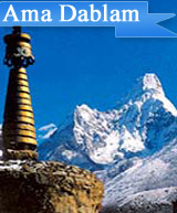
Ama Dablam Expedition
Ama Dablam is a mountain in the Himalaya range of eastern part of Nepal. The main peak is 6,812 meters (22,349 ft, the lower western peak is 5,563 meters (18,251 ft). Ama Dablam means "Mother's necklace"; the long ridges on each side look like the arms of a mother (Ama) protecting her child and the hanging glacier thought of as the Dablam, the traditional double-pendant containing pictures of the gods, worn by Sherpa women. For several days, Ama Dablam dominates the eastern sky for anyone trekking to Mount Everest base camp.
The normal route to climb mount Ama Dablam is from its South- West ridge. Most of the mountaineering beginners start their climbing through this Mount Ama Dablam 6812m. Ama Dablam is a small snowcapped peak of 6812m lying in the Everest region. This South - West ridge is the normal and most popular route to ascend the Mt. Ama Dablam.
This Mountain is considered to be the most technical & difficult to climb. The mountaineers have to cross-difficult ice rocks and steep snow climbing one their climbing route. Mountaineers usually have to pitch 3 high camps on the mountain of mount Ama Dablam 6812m.
To reach the first camp from base camp, the climbers have to pass the toughest and the difficult passing through the difficult saddle ridges; and then should turn to the north climbing up through the rocky ground and through the boulder. We are in Camp one now. From Camp I - one has to cross the rocky bowl and should climb the ridge via to the fixed lines to Camp II . From Camp II after crossing over severe rocks and ridge which lead you to a camp 2.
The climbing route from Camp II is mostly with the steep mixed alleyways of rock, ice and snow. The route leads to the slope climb to snow ground and then passes through steep snow and ice tunnel then finally along the snow ridge go to Camp III, From here to the summit, it is steep climb on snow and ice to the right of a huge hanging glacier. From the Top of mount Ama Dablam very charming sceneries of Mount Everest 8848m., Lhotse 8516m, Island peak, Makalu 8463m , Khumbu Himalayan and rest of the snowcapped surrounded mountains can be envisioned.
Pumoro Expedition
The Mount Pumori Base camp can be reached from Kathmandu - Lukla flight; and then trekking via Namche Bazaar, Thangboche - Pheriche and Lobuche. Mount Pumori is 7145m. High and ascent starts at 5,300m; which is beside a beautiful small lake from here you can get a beautiful sight of Mt. Everest and Kalapthar at 5545m.
Camp 1: After a 3 hrs walk you will reach camp 1 or advance base camp 5700m. After that you will have to walk the distance of 500m with the elevation of 40 to 65 degrees slopes. Mount Pumori has many rocks and mixed climb traverse, steep and exposed to wind narrow ridges, some ice walls, and one tunnel climb. Some times you may need fixed ropes also.
Camp 2: It starts at 6200m. It is located on a narrow ridge; so there is no fear of avalanches. The next 400m, Is an ice climb with 35-65 degrees above-5000m high, is the Ice walls, many crevasses, and the bigger avalanche danger from big seracs hanging from the shoulder of 6500m.
Now camp 3: It is too windy. At the height of 6850m, from where you can see Tibetan plateau; and you need rope here because of many crevasses and ice wall's way to summit. After that there are two climbing ranges; one from Tibet side and other is from Nepal side. Between these 2 sides the Nepal side is easier to Mount Pumori Summit. After this walk, the Summit is easy to reach on it's vertex Pumori 7145m.
Normal route: This is the easier route to climb this peak and most of the expedition coteries climbed this peak by applying this route. As you know Pumori is not easy as like the other mountains, there are difficult technical parts in this route as well. We suggest you that, you should take climbing Sherpa; who will guide you nicely to reach you on the top of Pumori. You need to have at least 3 camps after base camp to reach the summit. The base camp is just above Gorek Shep at the altitude of 5300m. After base camp, you can set up first camp at the altitude of 5,650m, around the phase of Mount Pumori.
You should set second camp at the ridge after the phase at the altitude of 6,000m. The most technical part for this peak is around camp 1 and 2. You should set camp 3 at the altitude of 6,480m, around the corner after the ridge.
You can ascend the summit from the camp 3 to the zenith of Pumori. Most of the climbers use this route every year for the expedition to Mt. Pumori to limb.
South - West ridge: Some very few climbers tried this route, but it is very difficult route. This route follows directly from the top of Kalapathar and goes straight over the ridge nearly by 75 Degree. As this route has lot of technical difficulties; so we suggest you to use the normal route for the Mt. Pumori and your group will comfortably reach on its Top. For the more information please check Himalayan Journal 1996 or American Alpine Journal 1997.